In 2019/2020, Swash reached out to peers, local experts and academics via LinkedIn to share learnings for a collaborative series of maps we produced of sand bypass and transfer systems around Australia.
The final maps are all available on the Swash website.
The benefits of sharing
One of the highlights of that creative process was the conversations the graphics prompted along the way. We received many positive comments about the value of sharing this information, and some new insights, too.
Over a period of nearly 20 years, members of the Swash team have been involved in several major sand bypass and transfer projects.
It’s surprising how often we see synergies that could be exploited, but which may not have been considered. By sharing information, we hope to open up that conversation.
Ideally, we want to be able to look at challenges like state erosion hot spots and consider as many options as possible to determine which systems may provide benefits.
It would also be terrific to undertake comparative cost/benefit analysis and regular monitoring across systems – and having a complete national map could be a good starting point.
Many people also commented on our original LinkedIn posts that we need to better educate the public about these systems and why they are needed. Again, we hope pooling resources and experiences could make a difference.
Here’s what we learned throughout our process.
The big picture
- There are more than 35 regular sand bypass and transfer systems operating Australia wide.
- More than 3,600,000 m3 of sand is shifted annually through these systems.
- West Australia (14) and south-east Queensland (9) have the most systems followed closely by Victoria (7).
- These are systems where more than 10,000 m3 of sand is relocated on an annual, or routine, basis and placed onshore or in the surf zone for beach nourishment.
- There are many other small and large systems and locations where sand is relocated on an ad-hoc basis.
Does size matter?
Not really. Each sand bypass and transfer system shifts various amounts of sand based on natural sediment transport requirements, boating access needs, available funding and operational capabilities.
The four largest systems are:
- 1,000,000 m3 – Murray Mouth (SA)
- 500,000 m3 – Gold Coast Seaway (QLD)
- 500,000 m3 – Tweed River Entrance Sand Bypass Project (QLD/NSW)
- 350,000 m3 – Gippsland Lakes Ocean Access, Lakes Entrance (VIC).
There are seven other systems that shift around 100,000 m3 annually: Gold Coast waterways, Maroochydore (bi-annually), Adelaide Beaches (x2 systems), Queenscliff, Mandurah and Dawesville.
Around one third of these systems move between 25,000 and 60,000 m3 sand annually.
Around one third of these systems move between 10,000 and 25,000 m3 sand annually.
How is sand collected?

Each system collects sand differently. Collection or ‘intake’ points have been classified into six general types:
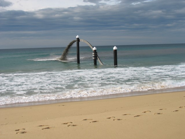
- Pumping jetty – where a series of jet pumps are fixed to a trestle type structure or jetty and pump sand to shore via a pipeline (e.g. Gold Coast Seaway and Tweed River).
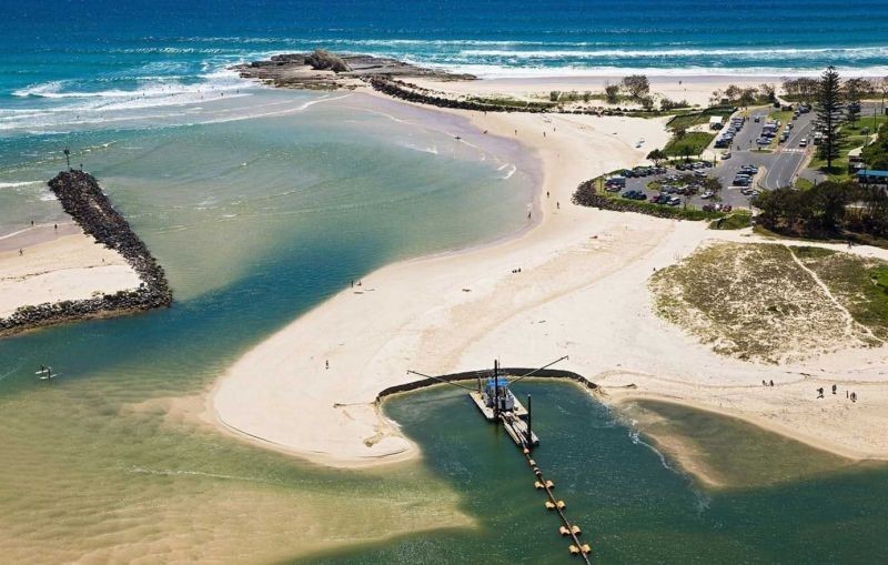
- Dredge – typically a cutter suction dredge is used in river, canal, port or marina entrances to improve navigational depths for boating access. Sand is then pumped to nearby beaches (e.g. Currumbin Creek, Port Fairy, Queenscliff, Kalbarri). A trailing suction hopper dredge is used at Tweed River and Lakes Entrance to relocate sand from the Entrance Bar to nearby offshore locations where sand is maintained within the active coastal zone.
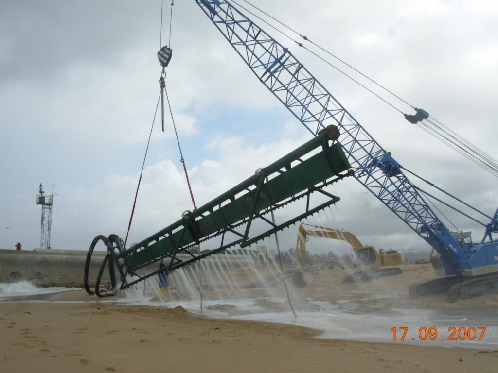
- Sand Shifter (refer image above) – these units are typically buried around six metres below the surface between the high and low water mark. Jet water is used to fluidise sand below the surface in order to pump sand away. A ‘crater’ is formed on the beach which fills in naturally over the following tides. These units can shift around 40,000 m3 per year each, with two often installed (e.g. Noosa, Woorim Beach)
- Sand Collection Unit (and excavator) – excavators are used to place sand in a sand collection unit which typically consists of a hopper, screens, water intake and a pump to fluidise sand into a slurry and pump through a pipeline (e.g. Adelaide Beaches, Mandurah, Dawesville).
- Excavator only – excavators are used to collect sand and stockpile or load into trucks for relocation to nearby beach (e.g. Narrabeen-Collaroy, Marengo-Apollo Bay, Geraldton).
- Excavator and jet pump – this combination can be used where sand has been stockpiled from previous dredging or trucking in. A water intake pipe is also required and sand slurry can then be transported to a permanent transfer pump station (eg. Jimmys Beach, NSW)
How is sand discharged?

In most of these systems, sand slurry is discharged via a polyethylene pipeline directly onto a beach where it may be further shaped and levelled by other plant.
Major pump stations, saltwater intake structures and onshore/offshore booster pumps may be required to assist with moving sand slurry the required distance to the allocated beach nourishment site.
Some sites have permanent pipelines in place which are either on the surface, buried under the sand or beneath pedestrian boardwalks. Some sites also have permanent pipelines which have been directional drilled under entrance channels. Other systems have temporary pipelines which are welded together and laid on the surface for use during sand transfer works.
Trucks are also used in some instances to relocate and place sand at the appropriate site.
Where are these systems located?
Australia’s mainland coastline length is just under 36,000 kilometres!
The geographic locations of these systems are shown in the infographics but are found around Australia and particularly in south-east Queensland, the southern half of West Australia and in Victoria.
They are located at high-density population cities such as Melbourne, Gold Coast and Adelaide through to regional cities and towns such as Lakes Entrance and Port Fairy in Victoria, Kalbarri in WA and Woorim Beach on Bribie Island QLD.
Breaking these systems down further, and noting there is some overlap, the number of systems could broadly be categorised by the following four location types:
- River, creek and lake entrances (18)
- Boat harbours, marinas and ramps (10)
- Beaches (7)
- Ports (3)
What is the purpose of each system?

There is typically more than one benefit to each of these sand bypass and transfer systems, which is great! In the infographics I have aimed to highlight the top two objectives or benefits for each system.
The five major benefits these systems provide are:
- Beach nourishment (and/or to maintain natural sediment transport)
- Coastal / Asset protection
- Boating access
- Flood mitigation
- Environmental.
In various ways these all provide social, economic and environmental benefits.
Who funds these systems?
Each sand bypass and transfer system is funded differently based on need and benefits. Typically, funding is provided by:
- State government
- Local councils
- Ports
- Waterway authorities
- Private developers/marina operators
- Local businesses (indirectly through council levies).
Get in touch
These learnings are summarised from Swash’s own diverse experience and extensive field knowledge, alongside the generously offered comments and reflections from peers on LinkedIn and in person.
If you’d like to talk more about any of the sand bypass and transfer system maps we created, please get in touch or connect with Damian on LinkedIn.


